


Drone mapping has changed the way surveyors, engineers, and construction teams collect spatial data. Flights that once took days on foot now take hours in the air. But speed alone doesn’t guarantee accuracy, and accuracy is everything in professional survey work.
That’s where a structured system of georeferenced markers becomes essential. Placing known reference points across a survey site gives the processed data a physical anchor in the real world. Without them, even the most advanced drone system can drift, skew, or misrepresent coordinates, creating serious downstream problems.
This article breaks down the core advantages of incorporating ground control points into your drone survey workflow and why skipping them is a risk no serious project can afford.
What Are Georeferenced Survey Markers?
Before exploring the benefits, it’s worth clarifying what these markers actually do.
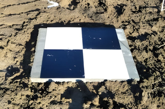
When a drone flies over a site, collecting imagery or laser-scanning data, it uses onboard GPS to record the position of each captured frame. However, consumer- and commercial-grade GPS devices sometimes carry positional errors of several centimeters or more, depending on signal conditions.
Survey reference markers are physical targets placed at known locations on the ground and precisely measured with a high-accuracy GNSS receiver or total station. During post-processing, the software uses these fixed positions to correct, scale, and align the aerial dataset to match real-world coordinates.
The result is a map, model, or point cloud that professionals can trust for engineering decisions.
Key Benefits of Using Reference Markers in Aerial Surveys
1. Centimeter-Level Positional Accuracy
The most compelling reason to use aerial mapping control markers is the dramatic improvement in accuracy they deliver. A drone flying without reference points may produce data with errors of 1–5 meters or more. Adding properly distributed markers can reduce that error to 1–3 centimeters.
- Eliminates positional drift caused by onboard GPS limitations
- Corrects for atmospheric interference during flight
- Produces data that meets engineering and cadastral survey standards
- Supports accurate volumetric calculations for earthworks and stockpile measurement
2. Built-In Quality Assurance for Every Project
Experienced survey teams use some markers as control inputs and reserve others as independent checkpoints. Checkpoints are not used in the data processing; they’re used to verify it.
- Provides an objective accuracy report for every deliverable
- Allows teams to catch systematic errors before sharing results with clients
- Creates a documented audit trail that satisfies regulatory requirements
- Builds confidence across engineering, legal, and planning workflows
3. Reliable Performance Across Diverse Terrain
One of the underappreciated strengths of a well-designed geospatial control network is its terrain-agnostic nature. Whether a site is flat, sloped, heavily vegetated, or urban, reference markers adapt.
- Works across construction zones, agricultural land, coastal areas, and forested terrain
- Compensates for GPS signal obstruction near buildings or tree canopy
- Supports both photogrammetry and LiDAR-based mapping workflows
- Scales from small parcels to large infrastructure corridors
4. Faster and More Accurate Post-Processing
Surprisingly, investing time in ground marker placement actually shortens the overall project timeline. When processing software has clearly identifiable, high-contrast targets to reference, it performs tie-point matching faster and with fewer errors.
- Reduces manual correction time during point cloud or orthomosaic generation
- Minimizes the need for additional flights to fill data gaps
- Enables smoother integration with CAD, GIS, and BIM platforms
- Produces cleaner outputs that require less quality-control editing
5. Stronger Client Trust and Project Credibility
Accuracy documentation matters beyond the technical team. Clients, contractors, and regulatory authorities increasingly expect surveyors to demonstrate how their data was validated.
- Accuracy reports backed by survey-grade checkpoint data add professional weight to deliverables
- Supports defensible evidence in boundary disputes or legal proceedings
- Demonstrates commitment to industry best practices
- Differentiates professional survey firms from operators relying solely on direct georeferencing
Best Practices for Deploying Control Markers on Site
Knowing the benefits is one thing deploying markers effectively is another. Follow these field-tested guidelines:
- Place markers across the full extent of the survey area, not just the center
- Use a minimum of five markers for standard mapping projects; more for complex or large sites
- Avoid edges and corners; only interior placement improves overall data correction
- Record coordinates with a calibrated GNSS receiver before the drone takes off
- Use high-contrast targets that stand out clearly in both RGB imagery and point cloud data
- Photograph and document each marker location for your project records
How Ground Control Points Fit Into the Broader Survey Workflow
Deploying ground control points doesn’t slow a project down it anchors the entire workflow to a standard of accuracy that every stakeholder can rely on. From initial site assessment through final deliverable review, a well-planned control network keeps the data honest.
The drone captures the big picture. The markers make it precise.
Final Thoughts
As drone survey technology becomes more accessible, the fundamentals of good geospatial practice remain unchanged. Reference markers are not optional extras; they are the foundation of reliable, defensible, and professionally credible survey data.
Whether you’re mapping a subdivision, monitoring a mine site, or planning infrastructure, placing geospatial reference targets across your project area is one of the highest-value steps you can take before the drone ever leaves the ground.
Precision is earned in the field, long before data processing begins.


Leave a Reply